Thursday, December 14, 2017

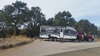
EL MORRO NAT’L MONUMENT, Ramah, NM


EL MORRO NAT’L MONUMENT, NM
RUN BY:  National Park Service
LOCATION:  Ramah, NM   (35.037101 -108.336303)

UTILITIES:  None
COST:  None
DISCOUNTS:  N/A

OUR RATING (1-5):  Category II.  Rating - 4


NOTES:  El Morro is an extremely small national monument next to the much larger El Malpais.  It is in beautiful country.  El Morro is free because the NPS found that keeping the personnel and equipment to take fees cost more than they made.  The campground is small but pretty.  Typical of the old NPS campgrounds, it is best for tents and truck campers. It was pretty and comfortable with a great view. The park is well worth visiting.

Environment:   High desert.  Juniper and pinyon pine with some ponderosa pine.
Amenities:  None
Dump:  No
Public Water:  Yes
Toilets:  Yes
Showers: No
Laundry:  No
Phone Service:  None
Nearest Propane:  unknown  - largest community is Grants, NM, 43 miles east.
Location:  Located on AZ-53 east of Ramah.  Coordinates to Park entrance:  35.043275  -108.338100
Proximity to shopping:  People working in the park seem to go to Grants, NM about 43 miles east.
Camping Population:  There were only three of us there in December 2017, but would expect it to be very diverse during high season.
Sites:  most were small and not particularly level.  Typical of NPS, made for tents. There is a 27 foot limit in the campground.


======================================================================
RATING KEY:    category - score 

Categories:  I - established campgrounds where one might spend a vacation or several days
                    II -  boondocking, dry camping where there are no designated sites and no amenities but
                               one might choose to stay for more than a night.
                    III - over-night areas 

You must remember that we are scoring 1 thru 5 according to things which are important to us: the environment, cost, amenities, location, safety, camping population, site, phone service 


* There are people who are not full-timers and van-dwellers by choice. We try hard not to be demeaning or assume that they are bad people but sadly, as you find in the poorer parts of a city, there seems to be more crime. Many call these people van-dwellers. That isn’t really accurate even though they do often live in vans. We know quite a few van-dwellers who have good incomes, are full-timers by choice and prefer a van to other types of vehicles. To try to show some respect for people who have a difficult lot in life, I’m calling them ‘residential campers’.  It is only when you get a high proportion of residential campers in an area that you find an increase in petty theft, etc.   
INDIAN WELL CG, Lava Beds NM, Tulelake, CA

INDIAN WELL CAMPGROUND
RUN BY:   Lava Beds National Monument (NPS)
LOCATION:   Lava Beds NM, Tulelake, CA   (41.717384  -121.504147)

UTILITIES:  none
COST:  $12                
DISCOUNTS:  Senior Access, Interagency get 50% discount.

OUR RATING (1-5): Category I.  Rating – 3.


NOTES:  We had a great time at Lava Beds.  It is a very interesting area with lots of lava tube caves to explore and some interesting petroglyphs at the northeast corner of the park.  As the name indicates, the majority of the land is lava beds. There are a number of caves you can explore. You must get a permit from the visitor’s center. Caves range from walk through to requiring significant skill.  The campground is not shaded but is among juniper, which gives a sense of privacy. 

Environment:  In a very open area with few trees, but nothing around this areas has many trees. 
Amenities:  none
Dump: No
Public Water: Yes
Toilets: Yes  (flush)
Showers: No
Laundry: No
Phone Service:  None
LocationFrom north: Take OR-39 south from Merrill to OR-161 at Hatfield. Turn right (west).  Follow 161 to Hill Road, a short distance west of Hatfield, and turn left (south).  Follow Hill Road south until it comes to a T-intersection. Turn right.  The park gate is just a short distance from the intersection.  Passing through the park gate and follow the Volcanic Legacy Scenic Byway (Rd 10) until you see the visitor’s center on your right. The left-hand turn into the campground is just beyond the turn into the visitor’s center. From the south: Go to Perez, CA on CA-139 and turn left on CA-97 to Tionesta, CA.  Here turn right (northwest) on Lava Beds Nat’l Monument Rd (which is also Hill Rd).  Follow this road for approximately 14 miles to the entrance to the campground on your right.  Coordinates for the campground are  41.717384  -121.504147. 
Proximity to shopping: Klamath Falls, CA is nearest for anything more than milk or gas. It is about 40 miles north.
Camping Population: varied.
Sites:   The sites were small.  Not many good for a unit as small as ours – 20ft.  We were parallel parked as we most of the other RVs. 


=====================================================================
RATING KEY:    category - score 

Categories:  I - established campgrounds where one might spend a vacation or several days
                    II -  boondocking, dry camping where there are no designated sites and no amenities but
                               one might choose to stay for more than a night.
                    III - over-night areas 


You must remember that we are scoring 1 thru 5 according to things which are important to us: the environment, cost, amenities, location, safety, camping population, site, phone service  

LAKE EUFAULA SP, Checotah, OK

LAKE EUFAULA STATE PARK
RUN BY:   State of Oklahoma
LOCATION: south of Checotah, OK   (35.3992  -95.5849)

UTILITIES:  Water and Electricity
COST:  $28
DISCOUNTS:  Senior ($2) and Disabled ($7)

OUR RATING (1-5): Category I.  Rating 4+


NOTES:  This is a lovely park in eastern Oklahoma. It is about half way between Checotah (north) and Eufaula (south), both communities of about 3,000 people. The lake is quite large.  There are several COE camping areas on the lake. None of them were open when we arrived on Dec 3rd.  This campground is very wooded with large sites. Each site has a picnic table, fire pit and grill.   Most of the trees look like oak. I would imagine that it’s pretty shady here when leaves are on the trees. We weren’t concerned about our solar panels since it has pole power.  If you are able, sites 90 and 91 are considered the top two sites, although most of them on this loop (#85-92) are very good. We are on site 90 and are at a point on the lake (see picture) with the lake not 25 ft away and a marvelous unobstructed view.        

Environment:  A nice wooded campground on a large lake in eastern Oklahoma at an elevation of around 607 feet above sea level. The trees appear to be oaks.
Amenities:  The campground has water and electricity, toilets, trash, and a laundry at a nearby sister campground. 
Dump:  Yes.
Public Water:  Water at each site.
Toilets:  Yes.
Showers:  No
Laundry:  Yes  (at the Dogwood Campground just down 150 otherwise about 6-8 miles away in Texanna, OK there is a nice laundromat.)
Phone Service:  Verizon 4G 2-3 bars
Nearest Propane: (unknown at this writing.)
Location:  If you are approaching on I-40 from the west, exit on OK-150 south and go 5.2 miles to the road to the campground which will be on your left.  If you are approaching on I-40 from the east, exit on US-69 going south. Follow US-69 about 8.6 miles to the exit for OK-150.  At the bottom of the exit ramp, turn right on OK-150 and go about 3.4 miles. The turn to the campground will be on your right. 
The office, on highway 150, is at this corner.  35.399630  -95.605087.  During weekday business hours you register for a campsite there. After hours and on weekends you register with the camp host. Follow the signs about 1.2 miles and you will see the camp host on the right.

Proximity to shopping: If you drive south on OK-150 about 3.2 miles away you will start encountering various businesses. There is a very small community called Texanna and less than 6 miles further is Eufaula. 
Camping Population:  The most sites occupied during our time here were four sites. Three of the four of us were full-timers, but this is the season for people like us to be moving through; late fall and early winter. The campground host said that the campground is almost always full during the summer.  
Sites:   Sites are paved with easy access to the water and electricity. Most of them seem rather level. There are some pass-through. A few are short, but there are quite a high percentage of excellent sites with good views. Very roomy with picnic tables and fire pits.


======================================================================
RATING KEY:    category - score 

Categories:  I - established campgrounds where one might spend a vacation or several days
                    II -  boondocking, dry camping where there are no designated sites and no amenities but
                               one might choose to stay for more than a night.
                    III - over-night areas 

You must remember that we are scoring 1 thru 5 according to things which are important to us: the environment, cost, amenities, location, safety, camping population, site, phone service 

* There are people who are not full-timers and van-dwellers by choice. We try hard not to be demeaning or assume that they are bad people but sadly, as you find in the poorer parts of a city, there seems to be more crime. Many call these people van-dwellers. That isn’t really accurate even though they do often live in vans. We know quite a few van-dwellers who have good incomes, are full-timers by choice and prefer a van to other types of vehicles. To try to show some respect for people who have a difficult lot in life, I’m calling them ‘residential campers’.  It is only when you get a high proportion of residential campers in an area that you find an increase in petty theft, etc.  


McCLELLAN CREEK NAT'L GRASSLANDS, TX

McCLELLAN CREEK NAT’L GRASSLANDS,  TX
RUN BY:   USDA Forest Service
LOCATION:   Gray County, TX.    (35.215144 -100.866271)


UTILITIES:  Water and Electricity
COST:  $10
DISCOUNTS:  Senior and Interagency passes (50%)

OUR RATING (1-5):  Category I.  Rating - 4

NOTES:  There is no way you can beat this for $5-10. (We’re seniors, so … wow!) There are two areas designated as campgrounds. We stayed in the McDowell Campground coordinates 35.215929  -100.866125.  We were directed here by the camp host as being one of the best areas in the park.  We were camped in a parallel spot right on the north end of the lake. The camp host said that there are a lot of ATV toward the southern end of the camping area.  It was a very pretty area and I’m sure it is filled with fishermen during the summer.  You are definitely out in the country but it is pretty and peaceful. 

Environment:   As the name says, you are in grasslands. The campground is on a lake in rolling grasslands. Elevation is around 2920.  We were there the first of December. The day was warm and the night was in the high 30s.
Amenities:  None
Dump:  Yes
Public Water:  N/A (water at sites)
Toilets:  Yes
Showers:  No
Laundry:  No
Phone Service:  Verizon 4G – 2 bars
Nearest Propane:  (unknown)
Location:   Exit I-40 at the  Farm-to-Market Rd 2477E exit. Coordinates for the exit are  35.181510                -100.847946.  The exit is 24 miles west of Alanreed, TX  and about 57 miles east of Amarillo, TX.  Follow the signs.  Go north on Farm-to-Market Rd 2477E for 4.2 miles to the entrance to the campground.  
Proximity to shopping:  We didn’t need any shopping but, having been there, I would suspect that Alanreed, about 28 miles east, is the closest shopping.
Camping Population:  We were there in early December. There was only one other person there.  
Sites:  Parallel, pull-through and back-in.  Big rigs should have no problems.

======================================================================
RATING KEY:    category - score 

Categories:  I - established campgrounds where one might spend a vacation or several days
                    II -  boondocking, dry camping where there are no designated sites and no amenities but
                               one might choose to stay for more than a night.
                    III - over-night areas 

You must remember that we are scoring 1 thru 5 according to things which are important to us: the environment, cost, amenities, location, safety, camping population, site, phone service 

* There are people who are not full-timers and van-dwellers by choice. We try hard not to be demeaning or assume that they are bad people but sadly, as you find in the poorer parts of a city, there seems to be more crime. Many call these people van-dwellers. That isn’t really accurate even though they do often live in vans. We know quite a few van-dwellers who have good incomes, are full-timers by choice and prefer a van to other types of vehicles. To try to show some respect for people who have a difficult lot in life, I’m calling them ‘residential campers’.  It is only when you get a high proportion of residential campers in an area that you find an increase in petty theft, etc.  


NORTH RIM CG, Grand Canyon, AZ

NORTH RIM CAMPGROUND
RUN BY: National Park Service
LOCATION:  Grand Canyon North Rim

UTILITIES: None
COST:  $18/night
DISCOUNTS:  Senior (50%) and other interagency passes.

OUR RATING (1-5):  Category I, Rating 3+


NOTES:  This campground is a reservation campground. We had already checked out some good BLM land just north of the park gate but decided to visit the campground not only so we could tell you about it but to see if they had any cancellations. We were lucky and got a site for one night.  We were across the driveway from the canyon rim.  The view of the canyon isn’t as spectacular as from the south rim, but this was very nice.  We were there just before they closed for the winter.  Lots of services, etc., during the regular season.


Environment:  High plateau. The campground is wooded. 
Amenities:  Laundry, gasoline and camp store (all closed by October) 
Dump:   Yes. 
Public Water:  Yes  (but closed by October)
Toilets:  Yes
Showers:   Yes  (but closed by October)
Laundry:   Yes  (but closed by October)
Phone Service:   No
Location:   Take US-89A to Jacob Lake, AZ and turn south onto AZ-67.  The campground will be 15-20 miles south of this turn. It is well marked. The coordinates for the turn into the campground are 36.213499 -112.058150
Proximity to shopping: There is a camp store and the lodge is about 3 miles away, the nearest shopping is Jacob Lake, and that is extremely limited.
Camping Population:  very diverse. 
Sites:  Typical of national parks, the sites are a bit tight for trailers. National Park campgrounds were originally designed for tents. They were nice sites. We were across the campground road from the actual canyon rim.


=====================================================================
RATING KEY:    category - score 

Categories:  I - established campgrounds where one might spend a vacation or several days
                    II -  boondocking, dry camping where there are no designated sites and no amenities but
                               one might choose to stay for more than a night.
                    III - over-night areas 


You must remember that we are scoring 1 thru 5 according to things which are important to us: the environment, cost, amenities, location, safety, camping population, site, phone service  

ARLIE MOORE, Bismarck, AR

ARLIE MOORE
RUN BY:  US Army Corp of Engineers
LOCATION:  Bismarck, AR    (34.271427  -93.203285)

UTILITIES:  Electricity
COST:  $14
DISCOUNTS:  50% for Sr and Interagency passes

OUR RATING (1-5):  Category I.

NOTES:  We were here in early December. Two of the three camping areas were closed.  The area we were in was right on De Gray Lake.  It is really quite pretty and there must be stripers in the lake because we encountered a government research unit studying the stripers.  There were a couple of RVs that appeared to be here for a long time, but there is a 14 day camping limit.  The couple next to us live about fifty miles away and spend time on the lake routinely throughout the year.  We stopped here to wait out a cold front. It got down into the high teens at night, so I’m sure that limited the campers.  There is at least one trail nearby although we did not hike it.

Environment:   Heavy growth of Oak and Loblolly pines on a lake. Elevation is about 430 ft.
Amenities:  None
Dump: Yes
Public Water:  Yes
Toilets:  Yes
Showers:   No
Laundry:   No
Phone Service:  Verizon very poor
Nearest Propane:  Southern LP Gas is at the intersection of Arlie Moore Rd and AR-7 just a couple of miles away from the campground. They were a bit pricy but quite convenient. 
Location:  We avoid interstates so we approached from the northwest and came down a small country road to intersect Arlie Moore Road (which is County Rd  254). The easiest way is to take AR-7 to Arlie Moore road (34.284138  -93.163258), turn west and follow the road to the campground.   Our site coordinates are  34.271427  -93.203285.
Proximity to shopping:
Camping Population:  Normal season population is unknown. COE campgrounds are usually quite diverse with a high percentage of locals because they’re not particularly easy to find and many people do not know about COE campgrounds.
Sites:   Some are not very level, but they are all paved and quite roomy.


=====================================================================
RATING KEY:    category - score 

Categories:  I - established campgrounds where one might spend a vacation or several days
                    II -  boondocking, dry camping where there are no designated sites and no amenities but
                               one might choose to stay for more than a night.
                    III - over-night areas 

You must remember that we are scoring 1 thru 5 according to things which are important to us: the environment, cost, amenities, location, safety, camping population, site, phone service 

* There are people who are not full-timers and van-dwellers by choice. We try hard not to be demeaning or assume that they are bad people but sadly, as you find in the poorer parts of a city, there seems to be more crime. Many call these people van-dwellers. That isn’t really accurate even though they do often live in vans. We know quite a few van-dwellers who have good incomes, are full-timers by choice and prefer a van to other types of vehicles. To try to show some respect for people who have a difficult lot in life, I’m calling them ‘residential campers’.  It is only when you get a high proportion of residential campers in an area that you find an increase in petty theft, etc.  


McHOOD PARK, Winslow, AZ

McHOOD PARK
RUN BY:   City of Winslow, AZ
LOCATION:  Winslow, AZ 

UTILITIES:  None
COST:  None
DISCOUNTS:  N/A

OUR RATING (1-5):  Category II.  Rating – 4.

NOTES:  Extremely nice for free.  The toilets were closed but the building looked relatively new and in good repair.  The area was neat and clean.  There were trash cans at each site and a dumpster.  There was a camp host. Although we never met him, I did see him outside once.  There is a small lake and a nice view.

Environment:   High desert.
Amenities:  None
Dump:  No
Public Water:  Probably when bathrooms are open
Toilets:  Yes  (closed in Nov)
Showers:  No
Laundry:  No  (nearest laundry in Winslow) 
Phone Service:  Verizon  4G-3bars
Nearest Propane:  Winslow
Location:  From east or west, exit I-40 at Winslow, AZ and follow 40BL to intersection with AZ-87. Turn south on AZ-87 and go 1.3 miles. Turn left (east) on AZ-99 and go 4.3 miles. The park entrance should be on your left.   Campground coordinates are  34.972157  -110.643410
Proximity to shopping:  Winslow – 5.6 miles away
Camping Population:   Unknown during busier times.  Other than ourselves there were only two others – a couple traveling west and a young woman who is a full-timer.
Sites:   Paved. Level. About half are pull-throughs.


======================================================================
RATING KEY:    category - score 

Categories:  I - established campgrounds where one might spend a vacation or several days
                    II -  boondocking, dry camping where there are no designated sites and no amenities but
                               one might choose to stay for more than a night.
                    III - over-night areas 

You must remember that we are scoring 1 thru 5 according to things which are important to us: the environment, cost, amenities, location, safety, camping population, site, phone service 

* There are people who are not full-timers and van-dwellers by choice. We try hard not to be demeaning or assume that they are bad people but sadly, as you find in the poorer parts of a city, there seems to be more crime. Many call these people van-dwellers. That isn’t really accurate even though they do often live in vans. We know quite a few van-dwellers who have good incomes, are full-timers by choice and prefer a van to other types of vehicles. To try to show some respect for people who have a difficult lot in life, I’m calling them ‘residential campers’.  It is only when you get a high proportion of residential campers in an area that you find an increase in petty theft, etc.  


MERRILL CG, Eagle Lake, Susanville, CA

MERRILL CAMPGROUND
RUN BY:   National Forest Service
LOCATION:  Eagle Lake,  Lassen National Forest, Susanville, CA
UTILITIES:  none
COST:  $10                
DISCOUNTS:  Senior Access, Interagency

OUR RATING (1-5): Category I.  Rating 4+


NOTES: The campground has what you might call three tiers; i.e.  three sets of two loops off a main road.  The top tier is under a heavy canopy of Ponderosa pines with limited view of the lake but has water, electric and sewage.  The middle tier is at the edge of the heavy canopy with a fair view of the lake and has water and electricity. The lower tier is as close to the lake as you can get with an unobstructed view of the lake but it is dry camping.  We stayed five days and probably would have stayed longer except the weather service was predicting snow and the smoke from the California fires was rolling in.

Environment:   Mountain lake with lots of Ponderosa pines.
Amenities:  Camp store, gasoline, propane, etc., at nearby marina.
Dump: Yes
Public Water: Yes
Toilets: Yes (flush)
Showers:  at Marina
Laundry: at Marina
Phone Service:  Verizon 4G-3bars
Location: Starting at the intersection of CA-139 and CA-36, take CA-36 west for about 3.6 miles.  Eagle Lake Rd turns right.  Follow Eagle Lake Rd for 14 miles to the entrance to Merrill Campground. Coordinates at entrance to campground are: 40.547965  -120.811689
Proximity to shopping:  Susanville, CA – approx. 18 miles away
Camping Population:  mostly locals in October
Sites:   Paved and Roomy. 


======================================================================
RATING KEY:    category - score 

Categories:  I - established campgrounds where one might spend a vacation or several days
                    II -  boondocking, dry camping where there are no designated sites and no amenities but
                               one might choose to stay for more than a night.
                    III - over-night areas 


You must remember that we are scoring 1 thru 5 according to things which are important to us: the environment, cost, amenities, location, safety, camping population, site, phone service  

PETRIFIED FOREST GIFT SHOP, Petrified Forest NP, AZ


PETRIFIED FOREST GIFT SHOP
RUN BY:  Petrified Forest/Crystal Forest Gift Shop
LOCATION:  South Entrance to Petrified Forest NP  (34.7914  -109.8971)

UTILITIES:  Electricity for $10/night during season
COST:   None
DISCOUNTS:   N/A

OUR RATING (1-5): Category III.  Rating 3.5

NOTES:  The Petrified Forest Gift Shop, which has the large parking lot used for over-night camping, is owned by the same people as the Crystal Forest Museum and Gifts across the street. Petrified Forest Gift Shop was closed for the season.  They have electric on ten sites for $10/night.  The electricity was turned off when we were there the nights of Nov 27 and 28th.  We have solar and are accustomed to boondocking, so we didn’t care. There were about six derelict cars sitting in front of the Petrified Forest Gift Shop. Other than that the place was clean and the Crystal Forest gift shop was beautiful. The staff were very friendly.  This place is less than one-hundred yards from the entrance to Petrified Forest National Park. The park well worth your effort to see. 

Environment:  Gravel parking lot in the middle of high desert.
Amenities:  None
Dump:  No
Public Water:  No
Toilets:  No
Showers:  No
Laundry:  No    (The Giant gas station at 28 N Hwy 77, advertises laundromat)
Phone Service: Verizon, 4G-2 bars
Nearest Propane:  The Giant gas station at 28 N Hwy 77, advertises propane & propane exchange
Location:  From Holbrook, AZ take AZ-77 south.  Shortly after crossing the Little Colorado River US-180 will be on your left.  Follow US-180 to Petrified Forest Road.  Petrified Forest Gift Shop is at that intersection.     34.7914   -109.8971
Proximity to shopping:  Holbrook, AZ is 18 miles away. 
Camping Population:  With a four day limit and being right on the road, it is mostly visitors like ourselves. There was a Class-A here when we arrived and we had a Class-B with us one night.
Sites:  There are concrete pads for picnic tables and electricity along the back of the parking lot. There are at least 12 such sites.  But the lot is extremely large and could handle several more rigs.


======================================================================
RATING KEY:    category - score 

Categories:  I - established campgrounds where one might spend a vacation or several days
                    II -  boondocking, dry camping where there are no designated sites and no amenities but
                               one might choose to stay for more than a night.
                    III - over-night areas 

You must remember that we are scoring 1 thru 5 according to things which are important to us: the environment, cost, amenities, location, safety, camping population, site, phone service 

* There are people who are not full-timers and van-dwellers by choice. We try hard not to be demeaning or assume that they are bad people but sadly, as you find in the poorer parts of a city, there seems to be more crime. Many call these people van-dwellers. That isn’t really accurate even though they do often live in vans. We know quite a few van-dwellers who have good incomes, are full-timers by choice and prefer a van to other types of vehicles. To try to show some respect for people who have a difficult lot in life, I’m calling them ‘residential campers’.  It is only when you get a high proportion of residential campers in an area that you find an increase in petty theft, etc.  


ROCKY POINT CAMPGROUND, Santa Rosa, NM

ROCKY POINT CAMPGROUND, SANTA ROSA SP
RUN BY:  State of New Mexico
LOCATION:   Santa Rosa, NM    (35.030737  -104.694920)

UTILITIES:  Electricity
COST:  $12
DISCOUNTS:  none

OUR RATING (1-5):  Category I.  Rating  3+

NOTES:  It is hard to say too much about Rocky Point since we arrived after dark and left the next morning. We were here Nov 30th.  We were the only ones.  Even in the dark we found a nice pull-through site.  It turned out that we would have had a view of the reservoir, if we had stayed. It is >8 miles from the highway but worth the miles for a nice place to stay.

Environment:   Open area above a reservoir.
Amenities:  None
Dump:  Yes
Public Water:  Yes
Toilets:   Yes
Showers:  No
Laundry:  No
Phone Service:  Verizon 4G – 2bars
Nearest Propane: (no idea. Probably a place in Santa Rosa.)
Location:  Actually the easiest way to get to the park is to follow the signs – it is well marked – or use GPS coordinates since there are a number of turns to get to NM-91 (also called Joe & Louie Page Rd) which goes right by Rocky Point Campground Rd.  (35.030737  -104.694920).  Exit I-40 and follow Historic Rte 66 to N. 2nd St. Turn north on N 2nd St. Go to the second intersection – Eddy Ave – and turn right. Go to N 8th St and turn left. This becomes Joe & Louie Page Rd (NM-91). Stay on this road to the campground. From the intersection of Eddy Ave and N 8th St it is 8.1 miles to the Rocky Point Campground Rd.   
Proximity to shopping: You are about 8.6 miles from Santa Rosa. 
Camping Population:  We were there in December so we were alone. I would guess that locals there to fish and use the lake would dominate warm weather.

Many, if not most, of the sites had these shelters.

======================================================================
RATING KEY:    category - score 

Categories:  I - established campgrounds where one might spend a vacation or several days
                    II -  boondocking, dry camping where there are no designated sites and no amenities but
                               one might choose to stay for more than a night.
                    III - over-night areas 

You must remember that we are scoring 1 thru 5 according to things which are important to us: the environment, cost, amenities, location, safety, camping population, site, phone service 

* There are people who are not full-timers and van-dwellers by choice. We try hard not to be demeaning or assume that they are bad people but sadly, as you find in the poorer parts of a city, there seems to be more crime. Many call these people van-dwellers. That isn’t really accurate even though they do often live in vans. We know quite a few van-dwellers who have good incomes, are full-timers by choice and prefer a van to other types of vehicles. To try to show some respect for people who have a difficult lot in life, I’m calling them ‘residential campers’.  It is only when you get a high proportion of residential campers in an area that you find an increase in petty theft, etc.  


ROSE LAKE, Cataldo, ID


ROSE LAKE
RUN BY:  Idaho Fish & Wildlife
LOCATION:  23982 S. Watson Rd., Cataldo, ID 83810
(47.554498  -116.458484)

UTILITIES:  none
COST:  none
DISCOUNTS:  N/A

OUR RATING (1-5): Category III. Rating 2.

NOTES:  Camping is in a parking lot above a boat ramp. Definitely just an overnight spot.  There are pit toilets but they were locked when we were there at the end of September.  There are a couple of tent camp sites.  We were the only people when we stopped.  This might not be a good option from Memorial Day to Labor Day.  

Environment:  wooded area 
Amenities:  None
Dump: None
Public Water:  None
Toilets: Pit
Showers: None
Laundry: None
Phone Service:  Verizon  extremely poor  1x-1bar
Location:  The turn off of ID-3 is easy to miss.  Exit I-90 at Exit 34 in Idaho. Turn south on ID-3 and go 1.6 miles to Watson Rd. Turn right onto Watson Rd.  About a half mile down there is a sign pointing left to the boat ramp. Turn left here.   (47.554498  -116.458484)
Proximity to shopping: the town of Rose Lake is a few miles south    
Camping Population:  Not really a camping area. Parking lot probably full of local boat trailers much of the year. 
Sites:   No sites.  You are in a parking area for boat trailers.


It was a rainy, overcast evening, so the picture doesn't do the lake justice.


====================================================================
RATING KEY:    category - score 

Categories:  I - established campgrounds where one might spend a vacation or several days
                    II -  boondocking, dry camping where there are no designated sites and no amenities but
                               one might choose to stay for more than a night.
                    III - over-night areas 


You must remember that we are scoring 1 thru 5 according to things which are important to us: the environment, cost, amenities, location, safety, camping population, site, phone service  

ANGEL VALLEY RD, Cottonwood, AZ

ANGEL VALLEY RD.
RUN BY:   National Forest Service
LOCATION:  Cornville, AZ   (34.812151  -111.894090)

UTILITIES:  None
COST:  None
DISCOUNTS:  N/A

OUR RATING (1-5):  Category III.  Rating 4+


NOTES: Angel Valley is 0.8 mi up a dirt road off of AZ-89A.  It is sometimes called 89B.  The camping area sits at top of a rise with magnificent views in every direction. There were three trailers, 1 van dweller, a class-C, class-A and 4 tent campers at one point during our stay.  The site is 9.5 miles north of Cottonwood and 11 miles south of Sedona.  We fell in love with Cottonwood.  Between the two, there is everything you could want.  Lots of places to visit – Montezuma’s Castle, Montezuma’s Well, Arcosante, Jerome, VbarV Ranch Petroglyphs, Oak Creek Canyon and Tuzigoot, just to make a few.  PLEASE, if you use dispersed camping, leave the area as clean, if not cleaner, than you found it. The future availability of such marvelous places is dependent upon clean thoughtful campers. 

Environment:   Dessert at around 4,000 ft plus elevation.  Jasper and Pinyon Pine. 
Amenities:  None
Dump:  No
Public Water:  No   (nearest water at Angel Valley meditation community about 1.5 miles away.)
Toilets:  No   (pit toilets at a trailhead about 0.8 mile away)
Showers:  No
Laundry:  No   (nearest laundry in Cottonwood)
Phone Service:   Verizon  4G 2-3 bars
Nearest Propane:  Camp Verde, AZ
Location:  Just off AZ-89A about half way between Cottonwood and Sedona. 34.812151  -111.894090
Proximity to shopping:  9.5 miles to Cottonwood.  11 miles to Sedona.  We preferred Cottonwood.
Camping Population:  Quite varied. We had a number of residential campers * who were good neighbors. The rest were full-timers. 
Sites:   N/A.  No site designation but there were, as mentioned above, 10 of us in there at one point. We could not have handled any more RVs but there could have been more tents. 


=====================================================================
RATING KEY:    category - score 

Categories:  I - established campgrounds where one might spend a vacation or several days
                    II -  boondocking, dry camping where there are no designated sites and no amenities but
                               one might choose to stay for more than a night.
                    III - over-night areas 

You must remember that we are scoring 1 thru 5 according to things which are important to us: the environment, cost, amenities, location, safety, camping population, site, phone service 

* There are people who are not full-timers and van-dwellers by choice. We try hard not to be demeaning or assume that they are bad people but sadly, as you find in the poorer parts of a city, there seems to be more crime. Many call these people van-dwellers. That isn’t really accurate even though they do often live in vans. We know quite a few van-dwellers who have good incomes, are full-timers by choice and prefer a van to other types of vehicles. To try to show some respect for people who have a difficult lot in life, I’m calling them ‘residential campers’.  It is only when you get a high proportion of residential campers in an area that you find an increase in petty theft, etc.  


THOUSAND TRAILS, Cottonwood, AZ

THOUSAND TRAILS RD
RUN BY:  Bureau of Land Management
LOCATION:  Cottonwood, AZ

UTILITIES: None
COST:  None
DISCOUNTS:  N/A

OUR RATING (1-5):  Group II – Rating 4.5


NOTES: We had had multiple comments by fellow nomads about the Sedona and Cottonwood areas. We decided to try this dispersed camping area because of its proximity to things we wanted to see.  It is just a few miles from several national monuments – Montezuma’s Castle, Tuzigoot, and more.  There appear to be at least three camping areas along this unnamed road. Each of them can handle a number of rigs of almost any size. We have an expansive view of beautiful mountains and look down on Cottonwood about 4 miles away. We are here in early November. The days are warm (68-75) and the nights are cool (40s). The area had a little bit of trash, but was basically clean. There is a 14 day camping limit. We do feel safe to leave Sinni here when we go exploring the area.  Nice weather, beautiful scenery, interesting area to explore, and everything we need close by – we may stay here the allowed 14 days. We do need to report that one of our neighbors has been coming here for years and was leaving very upset. We have two trailers with big generators. They aren’t close enough to bother us but they did bother them. They also said that there are many more residential campers* than in previous years and some of them have made quite a mess.   PLEASE, if you stay in dispersed camping, leave it as clean, if not cleaner, than you found it. The availability of such places is dependent upon thoughtful campers!!

Environment:   Open desert at an elevation of 3,440 ft.  Some shrubs that I’m guessing are desert mahogany. Many tribes used this plant for bows, etc.
Amenities:  none                                                       . 
Dump: none   (a Giant gas station about 4.4 miles away has a free dump.)
Public Water:  none  (We bought water for 30 cents a gallon at a water store in a shopping center <4 miles away.  We pulled along side his business and he ran a hose out to Sinni.) 
Toilets:  none
Showers:  none
Laundry:  none
Phone Service:  3-4 bars 4G with Verizon
Location:  4.4 miles east of Cottonwood, AZ on AZ-260.  Turn east on E. Thousand Trails Rd., then turn immediately left onto the road by the dispersed camping areas. Our coordinates are 34.666697         -111.963413
Proximity to shopping:  Around 4 miles to Cottonwood, which has anything you need. We got a prescription filled at their Walgreens, Atilla’s special dog food from a local vet, and incidentals at a Walmart.  We fell in love with Cottonwood.
Camping Population:  There is quite an array of nice rigs in the area. The lady next to us in an Rpod is a full-timer originally from Pennsylvania. There were a few campsites down toward the end of the road where there appeared to be residential campers.*
Sites:  none designated but you can see where others have stayed. Plenty of room.


=====================================================================
RATING KEY:    category - score 

Categories:  I - established campgrounds where one might spend a vacation or several days
                    II -  boondocking, dry camping where there are no designated sites and no amenities but
                               one might choose to stay for more than a night.
                    III - over-night areas 

You must remember that we are scoring 1 thru 5 according to things which are important to us: the environment, cost, amenities, location, safety, camping population, site, phone service 


* There are people who are not full-timers and van-dwellers by choice. We try hard not to be demeaning or assume that they are bad people but sadly, as you find in the poorer parts of a city, there seems to be more crime. Many call these people van-dwellers. That isn’t really accurate even though they do often live in vans. We know quite a few van-dwellers who have good incomes, are full-timers by choice and prefer a van to other types of vehicles. To try to show some respect for people who have a difficult lot in life, I’m calling them ‘residential campers’.  It is only when you get a high proportion of residential campers in an area that you find an increase in petty theft, etc.